Transmission expansion
As our province grows in population and industry, our energy needs increase. We’re constantly working to enhance our electrical service capacity and expand our natural gas service areas.
Our system expansion projects:
- Pointe du Bois renewable energy project;
- Portage la Prairie area restoration and expansion;
- Radisson to Henday transmission line (R44H);
- Silver to Rosser tap transmission line;
- St. Vital Transmission Complex.
Transmission explained
Learn more about transmission and its valuable role in delivering the reliable, affordable energy you count on.
From the start to the end point, potential effects to human, technical, and natural environments are part of the selection of a transmission line routing process.
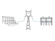
What is transmission? How does it fit into our system?
Watch to learn where our electricity comes from and how it gets to the places we use it.
The value of electricity exports
Watch our video to learn more about transmission connections and the value of exports to our customers.
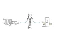
The value of reliability
Watch our video to learn more about transmission connections and the value they provide our customers by enhancing reliability.
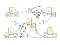
Why does Manitoba need new transmission?
Watch to learn how the demand for electricity has increased and how we need to change our system to accommodate the growing need.

How do we develop transmission lines?
Watch to learn how we work with communities to minimize the effects of transmission lines on people and the environment.
Bipole lines
Manitoba Hydro is known around the world for our development of transmitting high-voltage direct current (HVDC) electricity over long distances.
HVDC transmission helped untap the tremendous hydroelectric potential of the Nelson River in the 1960s, bringing electricity produced by generating stations on the river to southern Manitoba.
The Nelson River HVDC transmission system includes 3 lines called Bipole I, Bipole II, and Bipole III. Bipole refers to the positive (+) pole and a negative (−) pole which allows electricity to travel great distances without much loss of power.
Before Bipole III’s completion in 2018, over 70% of electricity generated in Manitoba was delivered to customers through Bipole I and Bipole II.
These 2 transmission lines run alongside each other for much of their 895-km route, starting at the northern Radisson and Henday converter stations near Gillam. Both lines end in the south at the Dorsey converter station just northwest of Winnipeg.
Because of their proximity to each other, a severe weather event could damage Bipole I and Bipole II at the same time. This would have left us unable to transmit enough electricity to meet demand, and result in extended outages and potential blackouts.
In 1996, high winds knocked down 19 towers on Bipoles I and II. For the first time in history, Manitobans were asked to reduce their non-essential power consumption while the towers were fixed over 4 days — they responded with an 8% reduction.
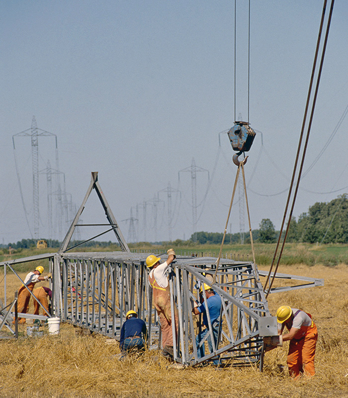
Enlarge image: Manitoba Hydro crew in a grass field build a new bipole tower on the ground.
The Bipole III HVDC transmission line has a total of 3,078 towers erected on a different route through western Manitoba and two new converter stations. It begins at the Keewatinohk converter station approximately 80 km northwest of Gillam, and ends at the Riel converter station just east of Winnipeg.
Bipole III provides 2,000 MW of additional capacity, and an independent and physically separate HVDC system. This significantly reduces the impact severe weather events may have on the HVDC system in the future, and increases the reliability of delivery of electricity to our customers.
Length of lines:
- Bipole I: 895 km;
- Bipole II: 937 km;
- Bipole III: 1,400 km.
HVDC Transmission System
The history and development of our HVDC transmission system.
Compressed natural gas station
Our compressed natural gas (CNG) station in southwest Winnipeg provides a back-up supply of natural gas to over 296,000 natural gas customers across southern Manitoba.
The CNG station allows us to respond in emergencies, plan outages for repairs without a disruption in supply, and provide a safe and more reliable distribution network for our customers.
How a compressed natural gas station works
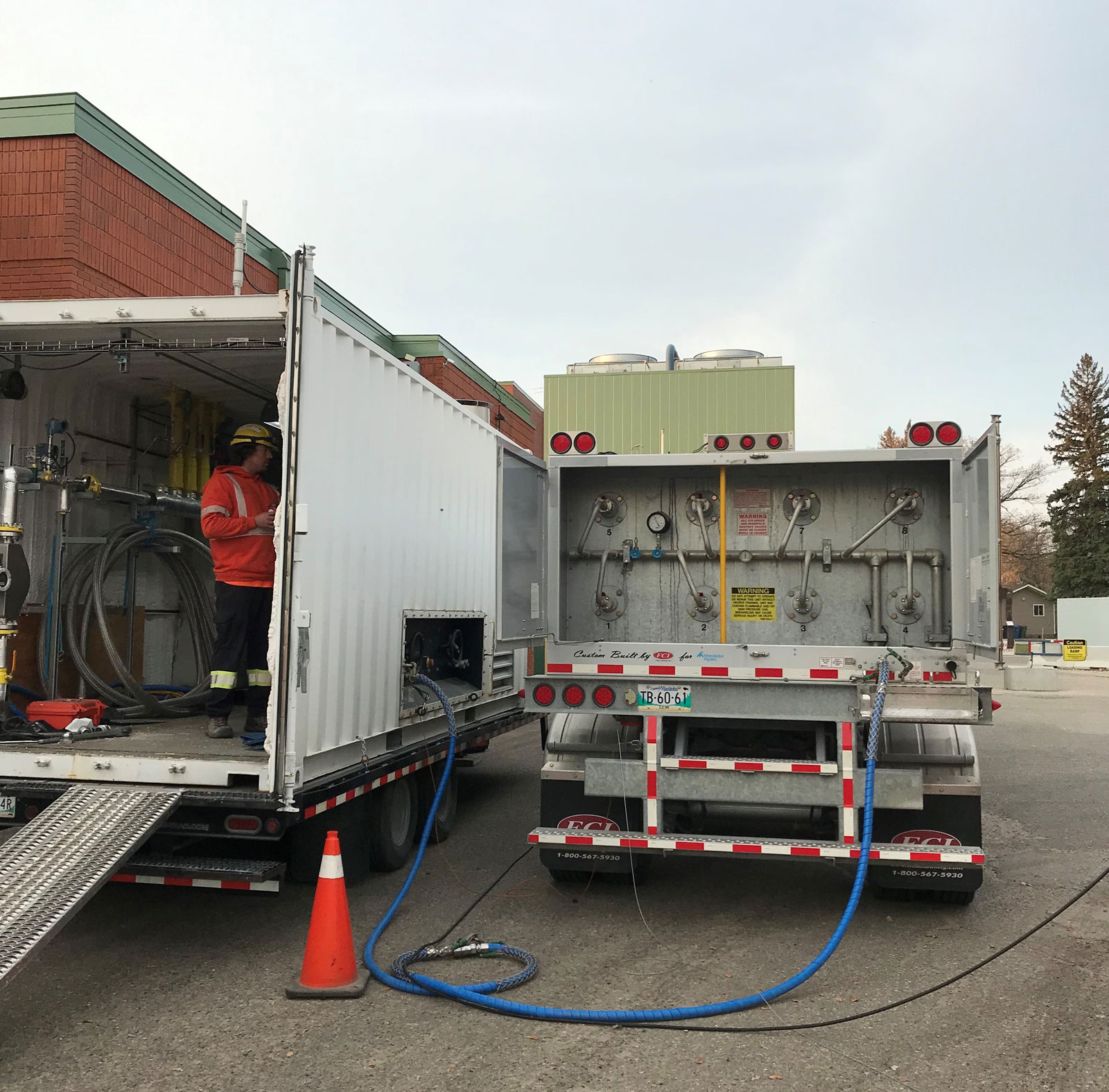
A compressed natural gas trailer in Dauphin supplying temporary gas during the Minell pipeline outage in October 2021. A trailer can hold 10 to 12 hours of natural gas. A second trailer can switch it out so there is a constant supply of gas to critical services.
Enlarge image: A compressed natural gas trailer supplying temporary gas during an outage.
The CNG station is located southwest of Winnipeg, close to most of our natural gas customers.
A CNG station looks similar to a gas station. If supply is disrupted in a natural gas line, CNG tube trailers can be filled with compressed natural gas and driven to the site. The transport truck connects to a local injection point in the distribution system and natural gas is restored to the customer while repairs are undertaken.
The need for a back-up supply became evident after an incident in Otterburne in January 2014 on TransCanada Corporation’s pipeline. Over 4,000 homes and approximately 15,000 people in south-central Manitoba were left without natural gas for days. Our electrical system was strained, as people heated homes with electric space heaters and stoves.
We can mobilize CNG trailers to inject natural gas into the local distribution system, which helps maintain pressure in the system and augments gas service to customers in cases where there may be an issue with the main pipeline.
We have multiple trailers that can operate in a rotation like we did in Dauphin in October 2021 due to a third-party damage to the Minell Pipeline.
Compressed natural gas station now in operation
Manitoba Hydro’s new compressed natural gas station near Winnipeg is now in full operation.
Minell pipeline
The Minell pipeline is our transmission pressure natural gas pipeline. The pipeline starts near Moosomin, Saskatchewan, travels to the Saskatchewan–Manitoba border, then north to Russell, Manitoba.
Transmission pressure pipelines are used to transport large quantities of natural gas. Compressor stations are built every 80 to 160 kilometres along the transmission pipeline, allowing pressure to be increased as needed to keep the gas moving.

The Minell pipeline crosses the Saskatchewan–Manitoba border and travels up to Russell MB.
Enlarge image: Map shows the Minell pipeline location in Saskatchewan and Manitoba.
Canada Energy Regulator
The Minell pipeline is regulated federally by the Canada Energy Regulator (CER). CER establishes and enforces the rules and regulations governing activity types permitted within the Minell pipeline’s prescribed area – an area 30 metres on either side of the pipeline’s centerline. The right-of-way (ROW) falls within the prescribed area and can vary in size.
We have placed permanent pipeline markers along the Minell pipeline to show its approximate location at roads, railways, and other sites.

The prescribed area and right-of-way on the Minell pipeline. Warning signs are posted along the pipeline.
Following CER regulations helps prevent contact with and damage to the pipeline. This also promotes the safety of everyone working and living near the pipeline and protects the surrounding environment. These regulations must be strictly observed by both landowners and us when working near and within the prescribed area.
If a person or company does not comply with CER’s regulatory requirements, CER may take enforcement actions such as monetary penalties or suspension of activities to ensure compliance.
Agricultural and working activities in the ROW
The closer your activity is to the ROW, the greater the risk of coming in contact with the pipeline. CER regulations require that before you perform certain activities within the pipeline’s ROW, you must have our written authorization.
Activities requiring written authorization include, but are not limited to:
- any activity that digs 30 cm or deeper in the prescribed area and the ROW;
- any activity resulting in a reduction or removal of the earth cover (depth of soil) over the pipeline;
- building anything (for example, shed or fence);
- cultivation to a depth of 45 cm or deeper (unless we notify you that it is unsafe to do so in certain areas);
- driving vehicles or mobile equipment over a pipeline (unless it is for low-risk agricultural purposes such as planting or disking, or on a public roadway);
- placing or storing anything on the ROW such as a berm, wood pile, or a parked vehicle.
Cultivation restrictions
Cultivation refers to preparing land for producing crops. Unless we advise you, you may perform shallow cultivation such as disking, plowing, harrowing, and pasturing without our written authorization. This does not include activities such digging or building on the ROW or prescribed area.
Should any of these activities result in a reduction or removal of the earth cover over the pipeline, you must have our written authorization before performing the activity.
Agricultural and working activities in the prescribed area
CER has established regulations over activities (agricultural and otherwise) that may be performed in the prescribed area. CER regulations require that before you perform certain activities such as driving across the pipeline, constructing a facility, or other work that can result in a ground disturbance, you must have our written authorization.
Ground disturbance restrictions
A ground disturbance is any activity that moves or penetrates the ground. Such activities can increase the probability of contact and damage to the pipeline. CER regulations recognize a ground disturbance as an activity within the prescribed area that involves any of the following:
- agricultural cultivation to depths of 45 cm or deeper below the surface of the ground;
- any activity, other than cultivation, to a depth of 30 cm or deeper (for example, digging);
- any activity resulting in a reduction or removal of the earth cover over the pipeline, such as, but not limited to:
- building a driveway, private road, lane, or parking lot or pad;
- building fences, driving posts, or drilling holes with an auger;
- building structures such as a pool, retaining wall, shed, or garage;
- clearing land, felling trees, stump removal, or planting or removing trees;
- crossing buried pipelines with heavy vehicles off a roadway;
- digging or excavating;
- deep tillage, trenching, or quarrying;
- ditching or ditch clearing;
- drain tiling;
- installing or maintaining overhead lines;
- installing a manure pit;
- land levelling, grading, or road projects;
- landscaping;
- laser levelling;
- pile driving, post pounding, or installing bollards;
- sodding or topsoil stripping.
You must not use mechanical excavation that results in a ground disturbance within 3 metres of the pipeline unless you follow the measures in the regulations.
The Minell pipeline is buried at a depth to prevent damage from normal agricultural activities (see cultivation restrictions above).
CER’s Agricultural Activities Near Pipelines requires that if your work or activity involves a ground disturbance you must request a line locate and receive our written authorization. This ensures you can safely perform your requested activity and that all pipeline locations are marked before you start the activity. We perform line locates at no cost to the landowner.
Moving vehicles and equipment across the pipeline
Our authorization for vehicle crossings is usually not required if the crossing is on a public roadway.
If not on a public roadway, moving vehicles or equipment over the pipeline can increase the stresses on the pipe. Such activities can reduce or remove earth cover over the pipeline and increase the odds that your equipment may damage the pipeline.
Driving with narrow tires or old equipment, especially in damp conditions, may cause ruts. Ruts 30 cm or deeper in the prescribed area are considered a ground disturbance. You must contact us before you move a vehicle or equipment if there is a risk of ruts. There may also be occasions when we implement restrictions, potentially reducing the 30 cm depth allowance within the prescribed area. Any such supplementary restrictions will be communicated by letter, and we will actively work with the affected landowner to resolve the situation.
Moving a vehicle or equipment across a pipeline, including over the ROW, is prohibited by CER unless:
- it is for low-risk agricultural purposes such as planting or disking;
- you have received our written authorization;
- it is within the travelled portion of a highway or public roadway.
We will consider all factors before authorizing the driving or moving of equipment over the pipeline. Such factors include, but are not limited to:
- creation of pressures on the pipe by static and dynamic loads;
- depth of earth cover above the pipeline;
- frequency of crossing activities;
- ground conditions;
- operating stresses experienced by the pipe;
- soil type;
- type of pipe;
- type and size of your equipment.
We may also consider the following to determine if the equipment can be used safely on the ROW and in the prescribed area:
- gross vehicle weight rating (GVW);
- load;
- number of axles;
- size;
- tire pressure or ground pressure;
- vehicle class.
Only we can assess this information and instruct how and where your vehicles and equipment can safely cross. Landowners should regularly review and confirm with us where you, your staff, and contractors can cross the pipeline.
Agricultural vehicles and equipment in the prescribed area
Most conventional agricultural equipment and vehicles can operate normally in low-risk areas of the prescribed area. Our authorization for vehicle crossings is not usually required if the crossing is on a public roadway but some larger equipment and vehicles may be too heavy. The maximum load depends on both the axle weight and the tire pressure or ground pressure.
We will assist you in determining the permitted maximum load to ensure you are not violating CER regulations. Heavy loads such as water, liquid fertilizer, manure, or grain may be a risk to the pipeline.
You must have our written authorization before operating heavy vehicles or equipment over the Minell pipeline if:
- the vehicle or mobile equipment does not meet RTAC (Roads and Transportation Association of Canada) Guidelines and have axle loadings exceeding 32,000 lbs;
- the loaded axle weight and tire pressures of the vehicle or mobile equipment do not meet the manufacturer’s approved limits and operating guidelines;
- we have notified you that the point of crossing at a location could impair the pipeline’s safety or security.
- the vehicle or mobile equipment belongs to one of the equipment listed below.
If the vehicle crossing is not for an agricultural activity, you must have written authorization from us before crossing the ROW.
CER regulations also require that certain types of equipment have our written authorization before operating in the prescribed area including, but not limited to:
- grain carts;
- grain/haul trucks, super B trains, and trailers carrying heavy loads (water, liquid fertilizer, manure, grain, etc.);
- augers and trenchers;
- backhoe and grader;
- deep tillage/rippers and tiling equipment;
- fence post pounders;
- laser leveler;
- skid steer;
- tree spade.
Constructing a facility
Prior to constructing any facility across, on, along, or under the prescribed area and ROW, you must:
- receive our written authorization to perform the activity;
- make a line locate request with us;
- follow all safety information that we provide.
Examples of facilities can include, but are not limited to:
- a built or installed structure (for example, a fence, concrete conduit structure, swimming pool, retaining wall, shed, rink, shed, gazebo, sign, tree, or any structure on the ROW);
- a drainage or irrigation system, including dykes, ditches, and culverts;
- a highway, private road, lane, parking lot, walkway;
- a pipe (for example, water main, sewer, gas line, oil line);
- a railway;
- a telecommunications line or power line;
- any vehicle parked on the ROW (for example, cars, boats, trailers, RVs, buses).
It is the responsibility of the person performing the ground disturbance in the prescribed area or ROW to ensure that a line locate request has been made. All buried facilities must be identified, and their locations marked, before any work or activity commences.
Working safely around the pipeline
For more information about working safely around the Minell pipeline, call us toll-free at 1-888-624-9376.
To apply for written authorization for your construction or excavation project, complete our online natural gas project review.
Learn more about CER regulations governing activities within the Minell pipeline’s prescribed area and ROW:
- Pipeline Damage Prevention Regulations - Authorizations (SOR/2016-124);
- Agricultural Activities Near Pipelines;
- Agricultural vehicles and equipment in the prescribed area;
- Guidance Notes – Canadian Energy Regulator Regulations for Pipeline Damage Prevention.
Know what’s below
As well as federally regulated pipelines, there may be provincially and locally regulated facilities such as pipelines and cables in your work area. These facilities may include oil and gas field gathering pipes, gas distribution systems, fibre optic telecommunication cables, water and sewer lines, and electrical cables.
Before you start any activity, contact Manitoba and Saskatchewan line locate services:
For emergency line locate requests, call both utilities at their toll-free numbers:
- Manitoba Hydro at 1-800-940-3447.
- SaskPower at 1-866-828-4888.
Portage la Prairie area restoration and expansion

Portage areas ongoing and planned projects.
Enlarge image: Map displaying Portage areas ongoing and planned projects.
Portage la Prairie and surrounding communities were some of the hardest hit by the powerful storm that ripped through southern parts of the province in October 2019. The damage to our system was unlike anything seen before and thousands of customers were left without power.
In the days to follow, crews worked tirelessly and in challenging conditions to rebuild hundreds of kilometres of distribution lines and entire sections of our transmission network to restore power as quickly as possible.
We are still working to repair and restore the transmission lines damaged by the October 2019 storm in the Portage la Prairie area, while we also plan to meet the growing electrical needs of the area.
Stay informed about the activities planned near you on our Portage la Prairie area map.
Parkdale–Neepawa (CN9) – complete
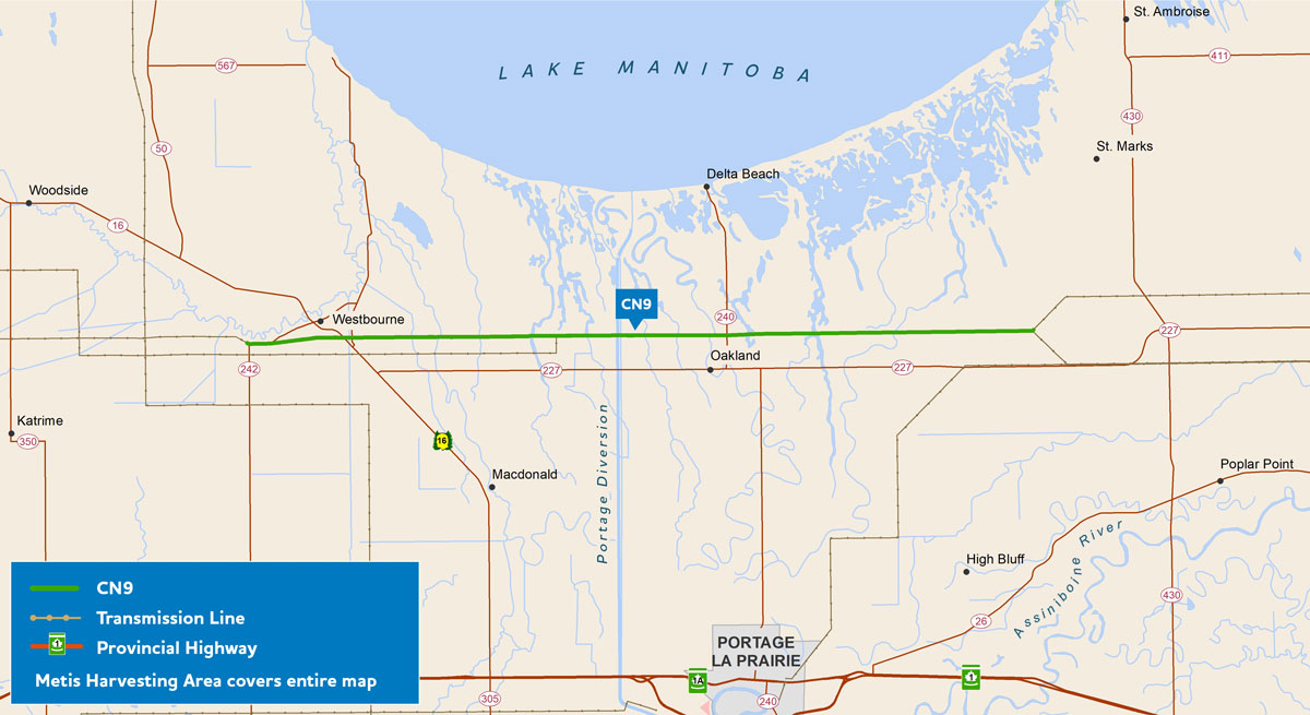
Parkdale–Neepawa CN9 restoration work.
Enlarge image: Parkdale–Neepawa work indicated with a green line on a map.
The CN9 line was damaged and subsequently cleaned up to remove damaged infrastructure. We needed to restore approximately 40 km of the 114 km-transmission line from Road 27W to Provincial Road 242.
Construction started in November 2021 and the line is now in-service.
Dorsey–Neepawa (D54N)
The D54N line needs 28 km of lines restrung of the 168 km-transmission line, and repair and/or replace damaged structures on this transmission line.
This repair work is anticipated to take place in 2023.
Brandon–Portage la Prairie (BP6/BP7)
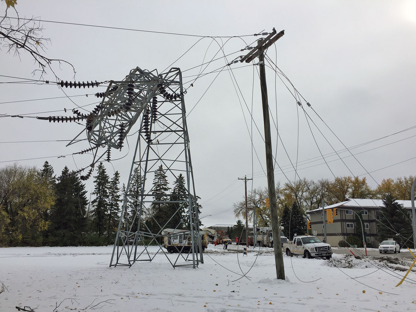
Over 50 towers on BP6/BP7 were damaged by the storm.
Enlarge image: A tower is bent in half beside a hydro pole with downed lines.
Work is continuing on some of the large-scale repairs and rebuilds in the Portage la Prairie area, including a double circuit transmission line between Brandon and Portage la Prairie (referred to as BP6/BP7).
The final preferred route for BP6/BP7 (solid green line).
Due to the extent of the damage, some sections of BP6/BP7 need to be entirely rebuilt with permanent replacements. Since development beside the line has grown and requirements for right-of-way widths have increased since the line was first built, we considered different routes for the sections to be rebuilt.
We received a license for BP6/BP7 on July 13, 2022 (license 3382).
Portage area capacity enhancement (PACE)
The PACE project is looking to the future and is planning expansion of our transmission system in the Portage la Prairie area with a new electrical station and transmission line to better serve customers in the area and meet growing electricity needs for years to come.
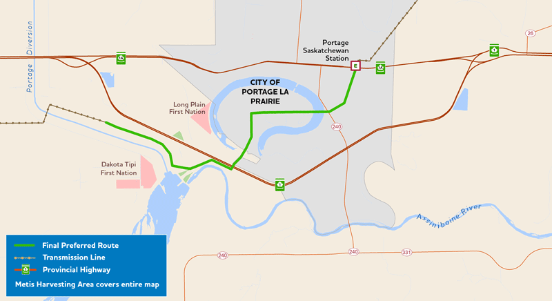
Dorsey to Wash’ake Mayzoon transmission line (D83W)
The final preferred route for the D83W transmission line (solid green line).
We are planning a new 230-kV transmission line from Dorsey converter station (northwest of Winnipeg) to the new, to-be-built Wash’ake Mayzoon station (west of Portage la Prairie).
The new transmission line will increase system capacity to meet growing electricity needs and enhance reliability for customers in Portage la Prairie and surrounding areas.
We submitted our environmental assessment report to Manitoba Environment and Climate for regulatory review in November 2022.
Wash’ake Mayzoon station
Wash’ake Mayzoon station will help enhance electrical reliability in the Portage la Prairie area. Growth in the Brandon and Portage la Prairie region, including the addition of new industrial customers, is increasing electricity demand. To meet these needs, we’re planning to build a new 230 to 66-kV electrical station and a short double circuit transmission line to connect into the existing P81C Tap transmission line.
We are working closely with Indigenous community coordinators to better understand concerns and work together to reduce effects in a manner that makes sense to those involved. When we needed a name for the new station, we reached out to the coordinators to ask if they had a suggestion. Our Dakota and Metis coordinators worked together to arrive at the name Wash’ake Mayzoon station. Wash’ake translates to power in Dakota, and Mayzoon translates to house in Michif. Although these 2 words wouldn’t make sense together in either language, together they represent a new way of working together on transmission projects and even sound (wa-shock-ee may-zoon) a little like electricity!
We received a license for Wash’ake Mayzoon Station on December 24, 2021 (license 3369).
Stay in the loop
Sign up for email notifications about the PACE project:
Schedule
All schedules are subject to change.
D54N schedule
- Repair storm damage: 2023.
BP6/BP7 schedule
- License received: July 2022 (completed);
- Construction start date: 2024.
Dorsey to Wash’ake Mayzoon transmission line schedule
- File environmental assessment report for regulatory review: November 2022 (completed);
- Licensing decision: fall 2023;
- Transmission line construction start: 2025.
Wash’ake Mayzoon station schedule
- License received: December 2021 (completed);
- Construction start: 2023.
Stay in the loop
Sign up for email notifications about Portage la Prairie area restoration and expansion events or new project materials:
Document library
Portage la Prairie area restoration and expansion project documents
Portage la Prairie area restoration and expansion project documents
- Newsletter (PDF, 696 KB);
- Map (PDF, 249 KB).
- Transmission line routing process (PDF, 1.5 MB).
- Alternating Current – Electric Magnetic Fields (PDF, 390 KB).
- Alternating Current Lines and Electronic Devices (PDF, 380 KB);
- Health Canada – Electric and Magnetic Fields from Power Lines and Electrical Appliances (PDF, 2 MB);
- International Commission on Non-ionizing Radiation Protection (PDF, 121 KB).
- Cattle & EMF (PDF, 45 KB);
- International Commission on Non-ionizing Radiation Protection (PDF, 121 KB).
- Keeping power lines clear of trees (PDF, 1.4 MB);
BP6/BP7 transmission lines replacement project documents
BP6/BP7 transmission lines replacement project documents
- BP6/BP7 final preferred route map – June 2021 (PDF, 1.1 MB).
BP6/BP7 Round 2
- BP6/BP7: What we heard summary (PDF, 1.7 MB);
- BP6/BP7: Preferred route map detail – March 2021 (PDF, 1.2 MB);
- BP6/BP7 information sheet – March 2021 (PDF, 178 KB);
- BP6/BP7 virtual information session presentation (PDF, 1.7 MB).
BP6/BP7 Round 1
- BP6/BP7: What we heard summary – March 2021 (PDF, 461 KB);
- BP6/BP7: Information sheet – October 2020 (PDF, 69 KB);
- BP6/BP7: Alternative route segments map – October 2020 (PDF, 3.7 MB);
- BP6/BP7: Virtual information session presentation – November 2020 (PDF, 4.4 MB);
GIS data – project infrastructure for download
This zip file contains spatial files in ESRI Shapefile format of the project infrastructure. They are viewable using geographic information system software. We recommend extracting the files to your computer, rather than opening them online. The .kml file will allow you to view the route(s) with software such as Google Earth®.
- Project components (Zip, 9 KB).
Brandon–Portage la Prairie (BP6/BP7) environmental assessment
Manitoba Hydro developed and submitted the environmental assessment (EA) report to the Environmental Approvals Branch of Manitoba Environment and Climate for review. The project received a Class 2 development Licence under The Environment Act (Manitoba) on July 13, 2022. We are planning to start the transmission line construction in 2023.
PACE project documents
PACE project documents
- D83W final preferred route map – November 2022 (PDF, 587 KB).
PACE Round 2
- Dorsey to Wash’ake Mayzoon: Virtual information session presentation – March 2022 (PDF, 1.5 MB);
- Dorsey to Wash’ake Mayzoon preferred route map – February 2022 (PDF, 439 KB);
- Dorsey to Wash’ake Mayzoon preferred route map detail – February 2022 (PDF, 347 KB);
- Dorsey to Wash’ake Mayzoon: What we heard engagement summary – February 2022 (PDF, 98 KB);
- Dorsey to Wash’ake Mayzoon information sheet – February 2022 (PDF, 691 KB);
- Dorsey to Wash’ake Mayzoon preferred route mapbook – February 2022 (PDF, 12.6 MB).
PACE Round 1
- Dorsey to Wash’ake Mayzoon: Virtual information session presentation – November 2021 (PDF, 1.2 MB);
- Dorsey to Wash’ake Mayzoon station: Transmission line index map of alternative route segments (PDF, 7 MB);
- Dorsey to Wash’ake Mayzoon station: Transmission line alternative route segments maps (PDF, 23.8 MB);
- Dorsey to Wash’ake Mayzoon: Information sheet (PDF, 307 KB);
- Wash’ake Mayzoon Station: What we heard summary (PDF, 103 KB);
- New station map (PDF, 259 KB);
- PACE Information sheet (PDF, 163 KB).
GIS data – project alternative route segments for download
This zip file contains spatial files in ESRI Shapefile format of the project infrastructure. They are viewable using geographic information system software. We recommend extracting the files to your computer, rather than opening them online. The .kml file will allow you to view the route(s) with software such as Google Earth®.
Do not download these files if they are beyond your computer’s or internet connection’s ability as they can cause your computer to temporarily stop working (require a restart).
- D83W final preferred route (Zip, 9 KB);
- D83W preferred route – Round 2 (Zip, 10 KB);
- D83W alternative route segments – Round 1 (Zip, 8 KB).
Dorsey to Wash’ake Mayzoon transmission line environmental assessment
This project requires approval as a Class 2 development under The Environment Act. An environmental assessment for the new transmission line route has been developed and was submitted to Manitoba Environment and Climate for approval on November 10, 2022. The report will also be made available on the Manitoba Environment and Climate Public Registry.
- D83W Environmental Assessment Report – November 10, 2022 (PDF, 59 MB).
Wash’ake Mayzoon station environmental assessment
We developed and submitted an environmental assessment (EA) report to the Environmental Approvals Branch of Manitoba Environment and Climate (formerly Manitoba Conservation and Climate) for review for Wash’ake Mayzoon station. The Wash’ake Mayzoon station received a Class 2 development Licence under The Environment Act (Manitoba) on December 24, 2021. We are planning to start the construction of the Wash’ake Mayzoon station in spring 2023.
Contact us
For more information about the Portage la Prairie area restoration and expansion project:
- Email Transmission & Distribution Environment and Engagement.
- Phone toll-free at 1-877-343-1631.
- Mail
Manitoba Hydro
Transmission & Distribution Environment and Engagement
360 Portage Ave. (5)
Winnipeg MB R3C 0G8.
Radisson to Henday transmission line (R44H)
We are planning to build a 230kV transmission line in northern Manitoba starting at Radisson and ending at Henday converter stations. It will be known as the Radisson to Henday transmission line (R44H).
More than 70% of the electricity delivered to our customers is generated at our northern generating stations. The northern collector system links the generating stations to our high voltage direct current (HVDC) system, which includes converter station infrastructure and the Bipole transmission lines.
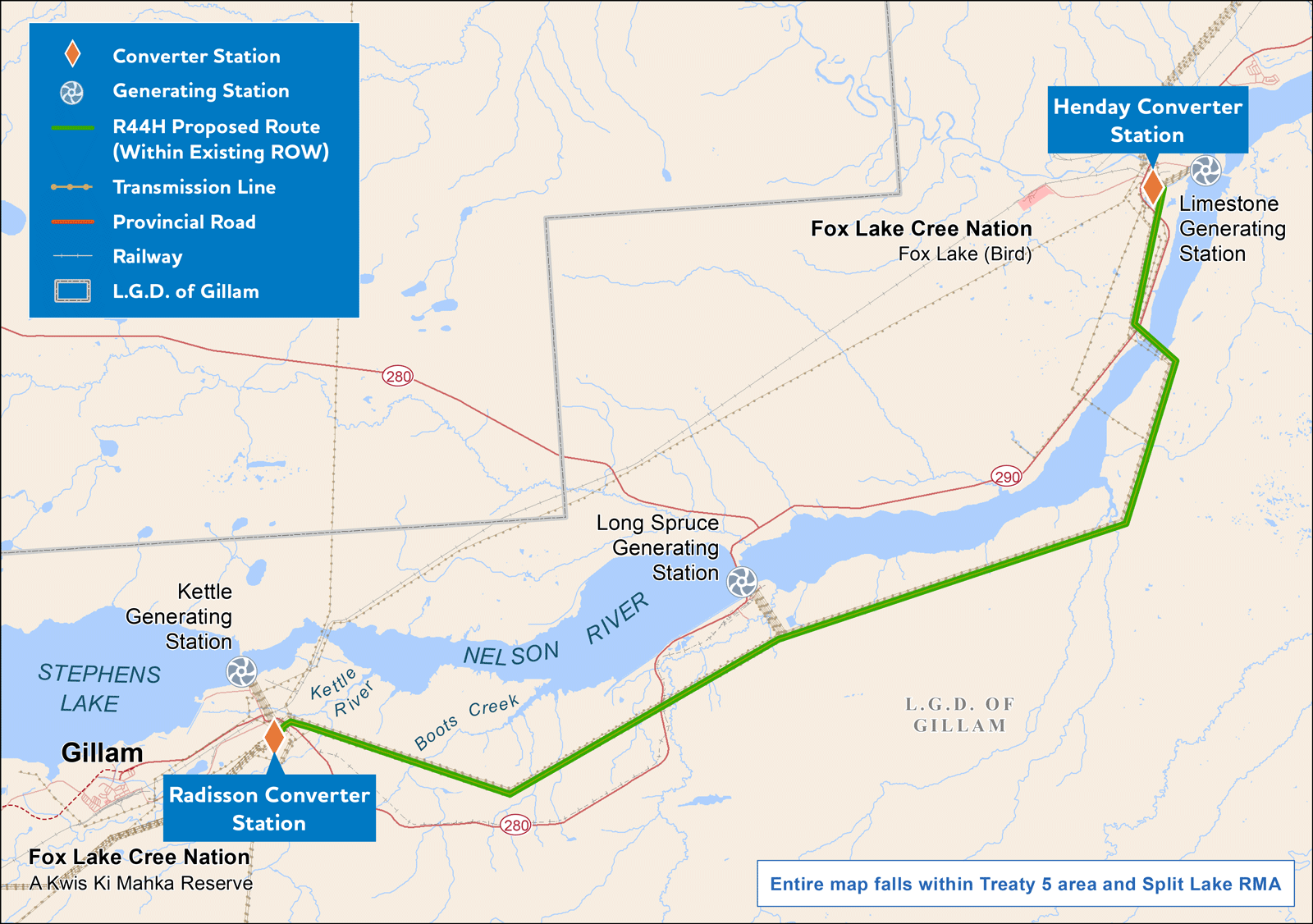
Radisson to Henday transmission Line R44H map.
Enlarge image: Radisson to Henday transmission Line R44H map.
We need more capacity within the northern collector system to transfer power between the northern converter stations. Due to ageing infrastructure of the HVDC system, the proposed R44H line would improve transmission reliability and reduce the risk of not being able to move electricity on to you.
The transmission line would be in an existing right-of-way corridor and the total length is approximately 42 kilometres. The work will also include electrical connections within the Radisson and Henday converter stations.
The proposed new transmission line will need approval as a Class 2 development under The Environment Act (Manitoba) before construction starts. We submitted the environmental assessment report to Manitoba Environment and Climate Change in December 2023. Read the environmental assessment report here:
- R44H environmental assessment report (PDF, 59 MB).
GIS data – project alternative route segments for download
This zip file contains spatial files in ESRI Shapefile format of the project infrastructure. They are viewable using geographic information system software. We recommend extracting the files to your computer, rather than opening them online. The .kml file will allow you to view the route(s) with software such as Google Earth®.
- R44H proposed route (ZIP, 7 KB).
Schedule
- environmental assessment engagement: May 2023 – September 2023 (completed);
- file environmental assessment report for regulatory review: December 2023 (completed);
- Anticipated construction start, if regulatory approval received: December 2024.
Contact us
For more information or to share your feedback:
- email Transmission & Distribution Environment and Engagement.
- Phone 1-877-343-1631
- Mail
Manitoba Hydro
Transmission & Distribution Environment and Engagement
360 Portage Ave. (18)
Winnipeg MB R3C 0G8
Silver to Rosser tap transmission line
We are planning to build a new 230kV transmission line to connect an existing transmission line (S65R) to Diageo Canada Inc.’s distillery facility in Gimli. This project will allow the Diageo Gimli distillery to reduce natural gas usage and use more hydroelectricity to power its facility.
The proposed transmission line will travel from the existing line (S65R) located west of Highway 7 near Fraserwood, Manitoba, to the Diageo Canada Inc. distillery facility located north of Gimli.
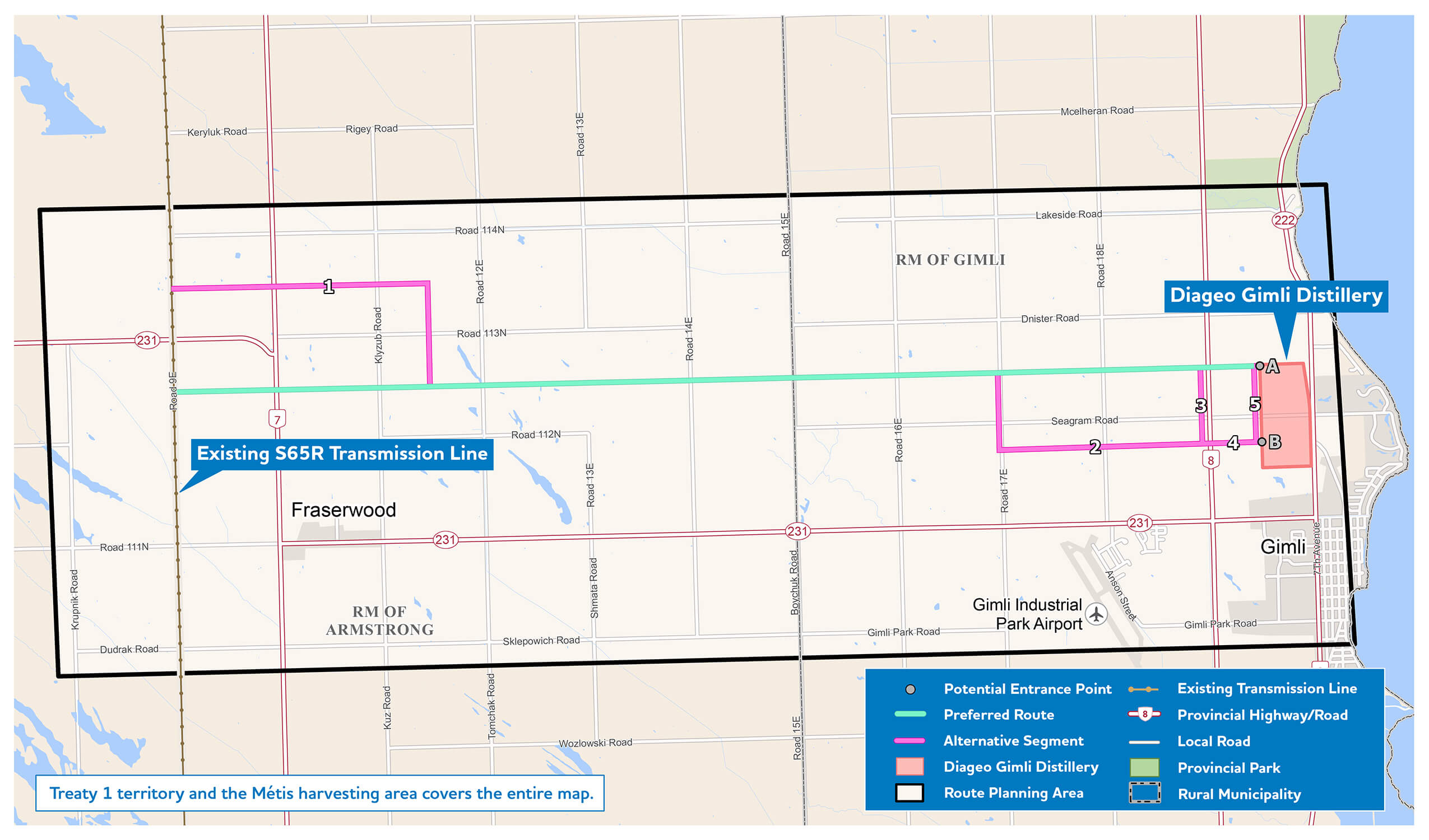
Preferred route (teal) and alternative route segments (pink) for Silver to Rosser tap transmission line.
Enlarge image: Map of preferred and alternative routes for Silver to Rosser Tap transmission line.
Transmission line routing process
To determine a final preferred route for a transmission line, we undertake a transmission line routing process that considers how well the different route options balance potential effects to socio-economic, technical and natural environments. Input received through the engagement and environmental assessment processes will assist in determining a final preferred route for the project.
Environmental assessment
This project is classified as a Class 2 development under The Environment Act. An environmental assessment report will be developed and submitted to the Environmental Approvals Branch of Manitoba Environment and Climate Change for review.
Project engagement
Our Round 1 engagement to identify and evaluate route options for the new transmission line is underway. Ask questions, voice any concerns, and share feedback with us to help inform our routing and plans:
Information sessions
We will be holding the following virtual information sessions:
Select the session you would like to attend and fill out the online form. You’ll receive a confirmation email with a link to the virtual session. If you need help, email us or call 1-877-343-1631.
Open house
To learn more about the project and share your feedback, join us at our open house:
- Fraserwood Community Hall, Thursday March 14, between 5:30 p.m. and 8:30 p.m.
Online survey
Tell us what you think about the preferred and alternative routes.
Start SurveyThe survey is open until March 31.
Interactive map & feedback portal
Use our interactive map and feedback portal to zoom into the preferred route and alternative route segments in more detail, provide your comments and suggestions, flag points of interest, and see what others are saying. The portal is open until March 31.
- Silver to Rosser tap preferred and alternative routes mapbook (PDF, 7 MB).
- Silver to Rosser tap preferred and alternative routes mapbook index map (PDF, 1.2 MB).
Schedule
- Round 1 - identify and evaluate route options: February - March 2024;
- Round 2 - select preferred route: May 2024;
- File environmental assessment report for regulatory review: summer 2024;
- Anticipated licensing decision: summer 2025;
- If licence approved, construction starts winter 2025/26.
This schedule is subject to change.
Contact us
For more information, email us or call toll-free at 1-877-343-1631.
Stay in the loop
Sign up for email updates about the Silver to Rosser tap project:
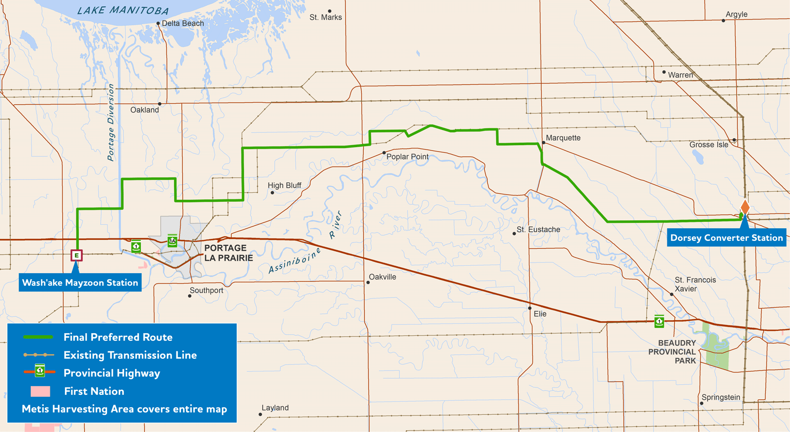
St. Vital Transmission Complex
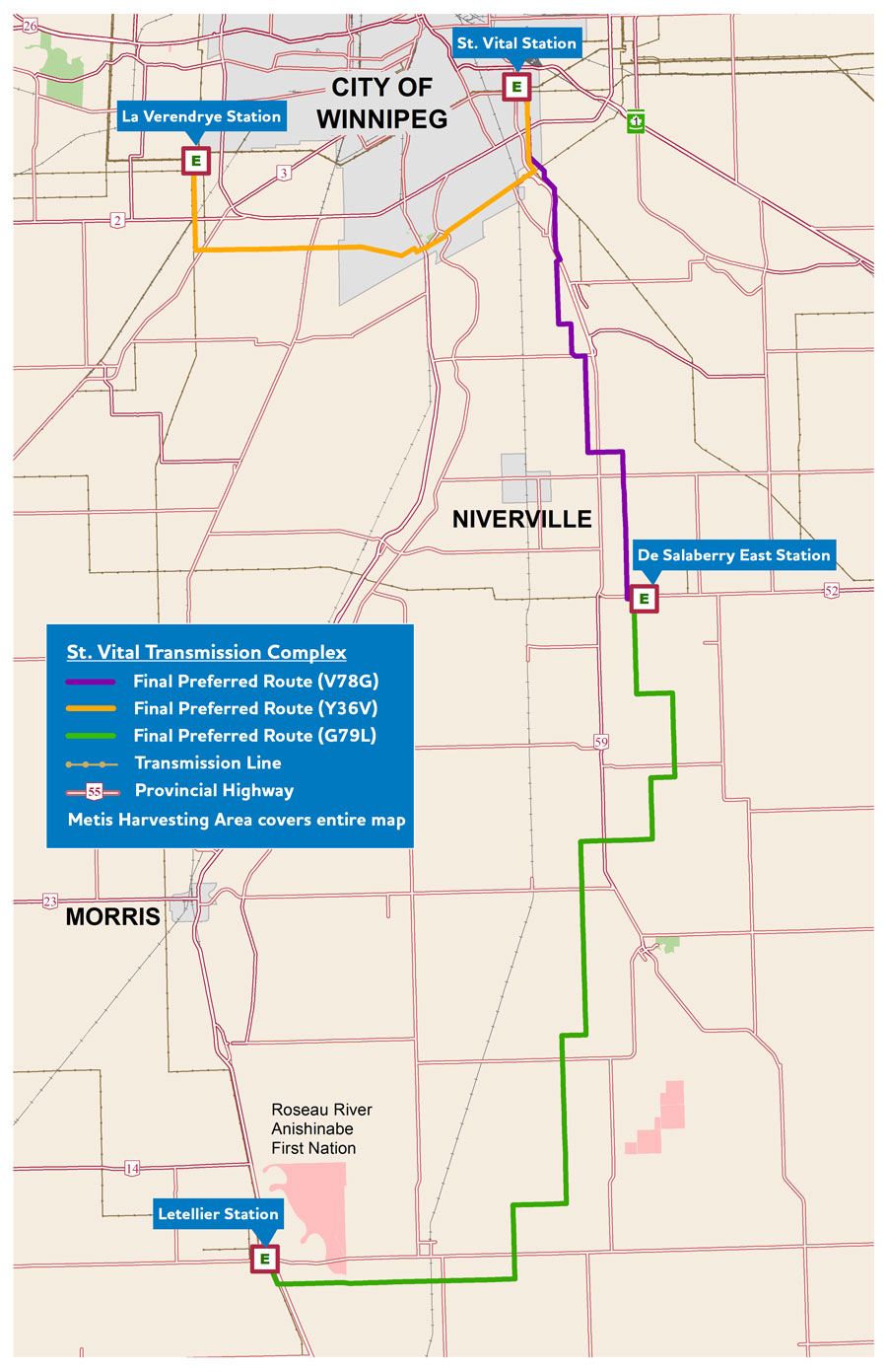
View the final preferred transmission routes starting from St. Vital Station.
Enlarge image: Final preferred transmission tower routes map.
We are building 3 230-kV transmission lines that will run between the new St. Vital, De Salaberry, Letellier, and La Verendrye stations. These lines will address growing electrical needs in south-central Manitoba, enable the Winnipeg network to withstand various severe outages, and promote reliability of our power system.
- The first portion of transmission line runs from St. Vital Station south to De Salaberry East Station (V78G). Construction started in January 2020, was completed in December 2020 and is now in service.
- The G79L transmission line continues south from De Salaberry East Station to Letellier Station. Construction started in September 2021, was completed in November 2022 and is now in service.
- The Y36V transmission line starts at the St. Vital Station and runs to La Verendrye Station. Construction started in September 2022 and will be located on the Southern Loop.
- The Sage Creek transmission corridor, part of the Y36V transmission line, was started in June 2020 and completed in October 2020. Areas disturbed by construction in the Sage Creek tall grass prairie were seeded in 2021 and rehabilitation was completed in summer 2022.
- Tower construction and the stringing of lines from the St. Vital Station to La Verendrye Station transmission line started in October 2022. Implosion sleeves will be used along the right-of-way starting in June 2023 and continuing sporadically until construction is complete. Learn more about why we use implosion sleeves.
![]() View the construction progress map.
View the construction progress map.
See the transmission line, tower locations, and the status of construction by tower.
The St. Vital Transmission Complex received a Class 2 development Licence under The Environment Act (Manitoba) on January 30, 2017.
Schedule
- Project announcement: August 2013;
- Public engagement round 1: August/September 2013 (completed);
- Preferred route determined: October 2013 (completed);
- Public engagement round 2: November 2013 (completed);
- Regulatory submission: May 2014 (completed);
- Licence received: January 2017 (completed);
- Construction start dates:
- St. Vital Station to De Salaberry East Station: January 2020 (completed);
- De Salaberry East Station to Letellier Station: September 2021 (completed);
- Sage Creek transmission corridor: June 2020 (completed);
- St. Vital to La Verendrye transmission line: September 2022 (completed).
- Construction completion: December 2023 (completed);
- Project in-service: April 2024.
This schedule is subject to change.
Stay in the loop
Sign up for email notifications about St. Vital Transmission Complex events or new project materials:
Public engagement
Feedback received through the public engagement processes helped inform route selection and environmental assessment. It was integral to ensure that we minimize effects on people and the environment.
Engagement goals for the St. Vital Transmission Complex were to:
- share information as it became available;
- obtain feedback for use in the assessment process;
- gather and understand local interests;
- integrate interests and concerns into the assessment process;
- discuss potential mitigation measures.
Through a 2-round approach, we presented the project to local municipalities, First Nations, the Manitoba Metis Federation, parties, and local community members throughout 2013.
Round 2: preferred route (completed)
During the second round of engagement, we:
- presented the preferred route and findings from Round 1;
- discussed potential route adjustments;
- discussed potential mitigation measures.
We undertook 4 open houses, an information session, various meetings and answered calls and emails. We thank all who participated and took the time to share their concerns and feedback with the project team.
Round 2 feedback helped us better understand the potential effects of the project and develop mitigation for concerns regarding the preferred route. The information gathered assisted in the finalization of the transmission line placement.
Round 1: alternative routes (completed)
During the first round of engagement:
- introduced the project to the public and Indigenous communities;
- produced feedback on alternative routes from the public and Indigenous communities;
- identified interests, opportunities, and constraints;
- gathered feedback that will feed into the environmental assessment.
During Round 1, we held 4 open houses, 3 stakeholder workshops, and answered calls and emails.
Document library
Environmental protection and management plans
Environmental protection and management plans
These plans are used as guides for contractors and field personnel during the construction of the St. Vital Transmission Complex. They help us meet environmental legislation requirements and protect the environment.
- St. Vital Station to La Verendrye Station construction access management plan (PDF, 1.5 MB);
- St. Vital Station to La Verendrye Station biosecurity management plan (PDF, 6.8 MB)
- St. Vital Station to La Verendrye Station construction environmental protection plan (PDF, 8.3 MB);
- St. Vital Station to La Verendrye Station construction environmental protection plan mapbook (PDF, 10.7 MB);
- St. Vital Station to La Verendrye Station cultural and heritage resources protection plan (PDF, 3.1 MB);
- St. Vital Station to La Verendrye Station erosion and sediment control management plan (PDF, 2 MB);
- St. Vital Station to La Verendrye Station rehabilitation and invasive species management plan (PDF, 2.2 MB);
- St. Vital Station to La Verendrye Station waste and recycling management plan (PDF, 2.3 MB);
- De Salaberry East Station to Letellier Station construction access management plan (PDF, 1.1 MB);
- De Salaberry East Station to Letellier Station construction access management plan mapbook (PDF, 22.3 MB);
- De Salaberry East Station to Letellier Station biosecurity management plan (PDF, 6.4 MB);
- De Salaberry East Station to Letellier Station construction environmental protection plan (PDF, 19.3 MB);
- De Salaberry East Station to Letellier Station construction environmental protection plan mapbook (PDF, 19.6 MB);
- De Salaberry East Station to Letellier Station cultural and heritage resources protection plan (PDF, 4.8 MB);
- St. Vital Station to De Salaberry East Station biosecurity management plan (PDF, 2.8 MB);
- St. Vital Station to De Salaberry East Station construction environmental protection plan (PDF, 5.4 MB);
- St. Vital Station to De Salaberry East Station construction environmental protection plan mapbook (PDF, 18.8 MB).
Final preferred route maps
Final preferred route maps
Localized preferred route maps:
- De Salaberry East Station to Letellier Station (G79L) transmission line mapbook (PDF, 3.5 MB);
- St. Vital Station to De Salaberry East Station (V78G) transmission line mapbook (PDF, 2.7 MB);
- St. Vital to La Verendrye (Y36V) transmission line mapbook (PDF, 2.8 MB);
- St. Vital Transmission Complex mapbook (PDF, 7.6 MB).
GIS data – project infrastructure for download
This zip file contains spatial files in ESRI Shapefile format of the project infrastructure. They are viewable using geographic information system software. We recommend extracting the files to your computer, rather than opening them online. The .kml file will allow you to view the route(s) with software such as Google Earth®.
- Project components (Zip file, 17 KB).
Public engagement: round 2
Public engagement: round 2
- Alternating Current Electric Magnetic Fields - November 2013 (PDF, 390 KB);
- Alternating Current Lines and Electronic Devices - November 2013 (PDF, 380 KB);
- Open House Storyboards - November 2013 (PDF, 933 KB);
- Open House Advertisement - October/November 2013 (PDF, 154 KB);
- Open House Postcard - October/November 2013 (PDF, 178 KB);
- Open House Newsletter - October 2013 (PDF, 1.1 MB);
- Open House Comment Sheet - October 2013 (PDF, 122 KB);
-
Map of preferred route (PDF, 852 KB).
- Map of preferred route - Grid 1 (PDF, 716 KB);
- Map of preferred route - Grid 2 (PDF, 674 KB);
- Map of preferred route - Grid 3 (PDF, 650 KB);
- Map of preferred route - Grid 4 (PDF, 622 KB).
Public engagement: round 1
Public engagement: round 1
- Open House Storyboards - August 2013 (PDF, 39 MB);
- Open House Advertisement - August 2013 (PDF, 168 KB);
- Open House Comment Sheet - August 2013 (PDF, 90 KB);
- Newsletter - August 2013 (PDF, 1.5 MB);
-
Map of alternative routes (PDF, 852 KB).
- Map of composite corridor and alternative routes - Grid 1 (PDF, 593 KB);
- Map of composite corridor and alternative routes - Grid 2 (PDF, 515 KB);
- Map of composite corridor and alternative routes - Grid 3 (PDF, 545 KB).
Environmental assessment
Environmental assessment
We have completed an environmental assessment for the St. Vital Transmission Complex and have submitted the report to Manitoba Environment, Climate and Parks (formerly Manitoba Conservation and Climate). This project is classified Class 2 development under The Environment Act (Manitoba).
The environmental assessment for the project included:
- characterization of the environment;
- identification of potential effects on people and the environment;
- determination of mechanisms to avoid or reduce potential adverse effects while enhancing beneficial effects.
An Environment Act Licence was issued on January 30, 2017, by Manitoba Environment, Climate and Parks (formerly Manitoba Conservation and Climate).
Contact us
For more information about the St. Vital Transmission Complex:
- Email Transmission & Distribution Environment and Engagement.
- Phone toll-free at 1-877-343-1631 or 204-360-7888 in Winnipeg.
- Mail
Manitoba Hydro
Transmission & Distribution Environment and Engagement
360 Portage Ave. (5)
Winnipeg MB R3C 0G8.
International power lines
Our international power lines (IPLs) are regulated federally by the Canadian Energy Regulator (CER). The CER establishes and enforces the rules and regulations governing activity types permitted within the right-of-way area of an international power line. CER rules and regulations apply to the right-of-way. In circumstances where no right-of-way is registered, CER rules and regulations apply to the prescribed area which is within 30 metres from either side of the centerline of the power line.
We have permanent warning markers on all of our international transmission towers.
Following CER regulations promotes the safety of everyone working and living near the IPLs. It helps prevent contact with, and damage to, the IPLs, and protects the surrounding environment. These regulations must be strictly observed by both landowners and Manitoba Hydro when working near and within the right-of-way or prescribed area (where no right-of-way is registered).
If a person or company does not comply with the CER’s regulatory requirements, the CER may take enforcement actions such as monetary penalties or suspension of activities to ensure compliance.
Locations of our international power lines
We have 5 IPLs:

- Glenboro to Peace Gardens
- Letellier to Drayton
- Manitoba-Minnesota Transmission Line
- Riel to Forbes
- Richer to Moranville
Agricultural and working activities in the right-of-way
The closer your activity is to the right-of-way, the greater your risk of coming in contact with an IPL. CER regulations require that before you perform certain activities within the IPL’s right-of-way, you must have our written authorization.
Activities requiring written authorization include, but are not limited to:
- Construction of a facility across, on, along or under an international power line.
- An activity that reduces the height of clearance between the overhead transmission line to the ground.
- An activity that causes a ground disturbance greater than 30 cm or any activity that removes coverage within the right-of-way area of an international power line (or if no right-of-way is registered for the international power line, within 30 metres from the centerline of the power line). A ground disturbance is any activity that moves or penetrates the ground excluding cultivation to a depth of less than 45 cm or any activity to a depth less than 30 cm that does not result in reduction of the earth cover.
- Operation of a vehicle or mobile equipment across an international power line outside of the travelled portion of a highway or public road.
Cultivation restrictions
Cultivation refers to preparing land for producing crops. Unless we advise otherwise, you may perform shallow cultivation (less than 45 cm in depth) such as disking, plowing, and harrowing without our written authorization. This does not include activities such as land grading for drainage within the right-of-way or prescribed area.
Constructing a facility
Prior to constructing any facility across, on, along, or under the right-of-way and prescribed area, you must:
- receive our written authorization to perform the activity;
- make a line locate request with us;
- follow all safety information provided by us.
Examples of facilities can include, but are not limited to:
- a built or installed structure (for example, a fence, concrete conduit structure, swimming pool, retaining wall, shed, rink, gazebo, sign, tree, or any structure within the right-of-way);
- a drainage or irrigation system, including dykes, ditches, and culverts;
- a highway, private road, lane, parking lot, walkway;
- a pipe (for example, water main, sewer, gas line, oil line);
- a railway;
- a telecommunications line or power line;
- any vehicle parked within the right-of-way (for example, cars, boats, trailers, RVs, buses).
It is the responsibility of the person performing the ground disturbance in the prescribed area or right-of-way to ensure that a line locate request has been made. All buried and overhead facilities must be identified, and their locations marked, before any work or activity commences.
Work safely near our IPLs
For more information about working safely around IPLs, call us at 1-888-624-9376.
To apply for written authorization for your construction or excavation project email us.
Learn more about CER regulations governing activities within an IPL’s prescribed area and right-of-way:
- Canada Energy Regulator: International and Interprovincial Power Line Damage Prevention Regulations – Authorizations, SOR/2019-347;
- Canada Energy Regulator: International and Interprovincial Power Line Damage Prevention Regulations – Obligations of Holders of Permits and Certificates, SOR/2020-49.
Click before you dig
There may also be provincially and locally regulated facilities such as pipelines and cables in your work area. These facilities may include oil and gas field gathering pipes, gas distribution systems, fibre optic telecommunication cables, water and sewer lines, and electrical cables.
Before you start any ground disturbance activity, contact ClickBeforeYouDigMB.com or call 1-800-940-3447.
For emergency line locate requests, call Click Before You Dig Manitoba at 1-800-940-3447.
Transmission line routing process
Transmission lines are sets of wires, called conductors, that carry electric power from station to station. Distribution lines then deliver that power to customers.
We use a process that is based on an internationally recognized methodology to select preferred transmission line routes. This process has been used on more than 200 transmission projects in North America and we used it first for the St. Vital Transmission Complex in 2013.
This process incorporates data gathering, fieldwork, and technical and environmental considerations. We also collect input from landowners, Indigenous communities, interested parties, the public, and project specialists in various fields. These perspectives help to minimize the overall impact of the project.
Route selection timelines depend on the project. They are closely associated with engagement and environmental assessment.
How we select a preferred route
There are a few stages in the transmission line routing process. These 5 stages outline how an area with many possible routes will lead to a final preferred route:
-
Determine a route planning area

- We choose the start and end points and develop a broad route-planning area based on opportunities and constraints on the landscape.
-
Plan alternative routes

- We draw segments connecting the start and end points within the route-planning area. These segments form alternative routes that we present during the engagement process. Project specialists who represent different perspectives including agriculture, heritage, and engineering also provide feedback.
-
Develop mitigative segments

- We add or modify route segments based on feedback during the engagement process and from project specialists. A mitigative segment is an addition that is made to part of the route based on feedback.
-
Determine a preferred route

- A comparative evaluation of alternative routes is done to choose a preferred route that is presented during the engagement process. Our project specialists focus their evaluations on this area to better understand potential effects of the preferred route on people and the environment.
-
Finalize the preferred route and submit an environmental assessment report

- After our preferred route presentation, we consider potential changes based on feedback from the engagement process and project specialists. After incorporating that feedback, we determine a final preferred route and present it to Manitoba Environment, Climate and Parks for review. The provincial regulator considers comments and questions from the public and Indigenous communities when they determine whether to issue an Environment Act Licence for the project.
These are general steps in transmission line routing. Some projects, based on their complexity, may need more or fewer steps to determine a final preferred route.
- Moving between each stage (PDF, 75 KB)
The decision-making process cycle: planning; feedback and analysis; comparative evaluation; and selection.
How we develop project criteria
Engagement process feedback helps to develop criteria that will be used to evaluate the strengths and weaknesses of route options. These criteria represent the natural, the built, and engineering perspectives.
Examples of criteria:
- natural environment: natural forest, wetlands, stream and river crossings;
- engineering: project cost, existing transmission line crossings, length;
- built environment: proximity to residences, land use and capability, historic resources, public use areas.
We then compare a subset of routes to select a preferred route. We take into account:
- cost;
- community considerations;
- reliability;
- risk to schedule;
- built environment.
Mitigative segments
A mitigative segment is a part of the route that is added to the transmission line routing process based on feedback during the engagement process or from our project specialists. These segments are added to address concerns or a potential effect on the landscape.
We evaluate these segments for technical feasibility and cost. We also consider whether or not the segment will shift effect from one landowner to another. If our evaluations deem the new segments are reasonable, they are incorporated into the comparative evaluation of routes to determine a preferred route.
How we determine the final preferred route
We work with a range of environmental, socio-economic, and technical specialists. We work to balance concerns and feedback from the Indigenous communities, landowners, project specialists, interested parties, and the public. Our goal is to achieve consensus between the project team on the final preferred route. The route is considered final once approved by the regulator.
Contact us
For more information about the transmission line routing process:
- Learn more about our transmission projects.
- Phone toll free at 1-877-343-1631.
- Email Transmission & Distribution Environment and Engagement.