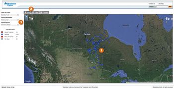
View information on water levels and related weather conditions around the province. Go to the hydrological data application.
How to use the application

Enlarge image: Screen shot of the Real Time Hydrological Data application.
- Select a gauging station by clicking on a coloured dot.
- Zoom or move the map.
- Change the map view.
- Alternate between the map view and a list of stations.
- View the stations that measure the data indicated.
The readings are displayed graphically in charts and can also be downloaded in Microsoft Excel spreadsheets. Data are presented in metric.
The near real-time information presented on this website is received via satellite or land-line transmissions from hydrometric gauging stations managed by Manitoba Hydro, Water Survey of Canada, and Manitoba Water Stewardship. The name of the station operator is displayed in the station detail page.
This website is updated daily.
Parameters
The majority of stations represented are hydrological, meaning they monitor water levels and water temperature. There are some stations which also record weather data. The type of measurement collected is referred to as a parameter. Parameters are distinguished by a 2 character “SHEF” code. There are 9 different parameters shown on this site:
- HG - water level
- TW - water temperature
- TA - air temperature
- UD - wind direction
- US - wind speed
- UG - wind gust
- PC - precipitation
- XR - relative humidity
- PA - atmospheric pressure
In the application, click on one of these links, or on a gauging station (coloured dot) to find out which measurements are collected at that station.
For a given parameter, 2 kinds of data are shown, if available:
- Continuous - refers to the past week’s inventory of individual readings collected.
- DayMean - contains the daily average of the continuous readings collected for each day over the past year.
Wind-eliminated levels
Weather conditions, such as wind and barometric pressure, can cause water levels to differ substantially at various points on Lake Winnipeg.
In order to determine the average level of the lake at a given point in time, a smoothed wind-eliminated level is determined. The regulation of the lake is based upon this wind-eliminated level.
Water levels are recorded continuously at 8 water level gauges around the lake and it is from these levels that the wind-eliminated level is calculated.
Disclaimer – The data on this website are preliminary and are being transmitted automatically without verification or review for quality assurance. Subsequent quality assurance and verification procedures may result in differences between what is currently displayed and what will become the official record. Manitoba Hydro does not warrant the quality, accuracy, or completeness of any information, data, or product from these web pages.
