Project overview
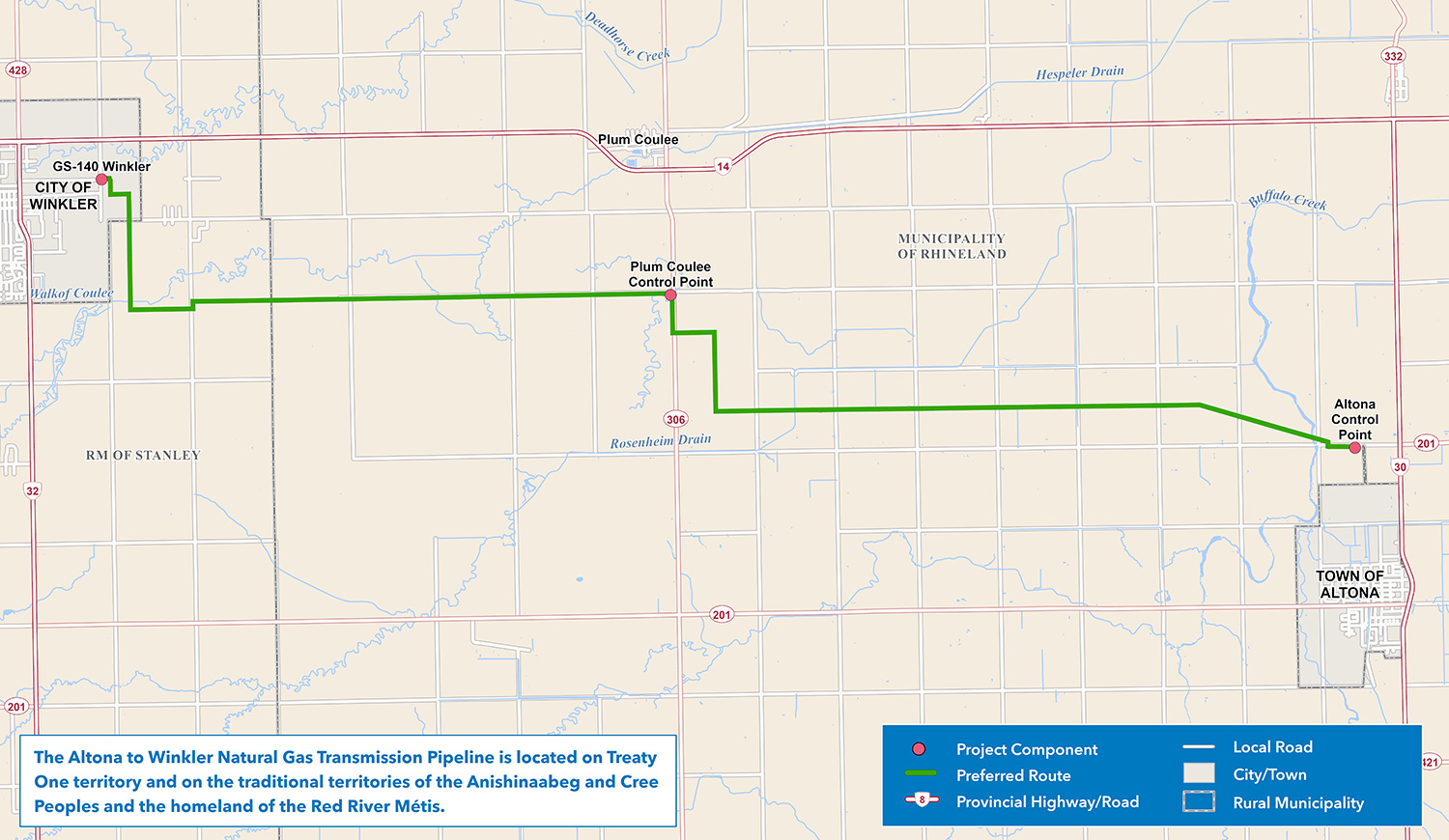
The final preferred route for the Altona to Winkler gas transmission line (solid green line).
Enlarge image: The final preferred route map from Altona to Winkler.
The Altona to Winkler Gas Transmission Project is a proposed 30-kilometre, 8-inch steel natural gas transmission line to improve the capacity of the regional gas transmission system in southern Manitoba. The line will extend from a site north of Altona to a connection point on the east side of Winkler, where it will connect to existing infrastructure owned and operated by TransCanada (TC) Energy Corporation.
The purpose of this project is to increase the supply of natural gas to the Altona and Winkler regions in response to growing customer demand. The existing infrastructure has reached its capacity limits, necessitating expansion to support ongoing regional development. Key drivers of this demand include urban growth, the expansion of cereal crop production, and a shift by some users from alternative energy sources to natural gas.
The proposed transmission line traverses the Rural Municipalities of Rhineland and Stanley, the communities of Reinfeld, Altona, and Winkler and is located on Treaty 1 lands, the original territories of the Anishinaabeg, Dakota, Anishininewak and Ininewak, and the National Homeland of the Red River Métis. We acknowledge these nations who have occupied and cared for these lands for thousands of years and their longstanding cultural and spiritual connections with the land. Through this we recognize the importance of learning and considering the unique perspectives these nations share throughout the project.
Construction methods for this project include trenching and horizontal direct drilling. Trenching involves excavating the ground and placing the transmission line within the excavated area. A typical trench depth is 1.3 meters, and the top of the pipe lays 1 meter below the surface. Horizontal direct drilling is used to install the transmission line where it crosses drains, railways and roadways. It is a technique used to install underground utilities, like pipelines. A tunnel that follows an arc shape is drilled under the designated area, and the transmission line is pulled through the drilled underground tunnel, resurfacing on the opposite side.
This project is classified as a Class 2 development under The Environment Act. An environmental assessment report will be developed and submitted for this project.
How to participate
We thank everyone who provided their feedback and participated in the engagement process for this project. While our formal engagement process to inform the environmental assessment has ended, we remain open and responsive to any questions or concerns that may arise through the project’s construction and operation. The project webpage will continue to be updated as the project progresses through the regulatory review process and project construction.
For additional feedback and concerns, email us at projects@hydro.mb.ca or call 1-877-343-1631.
Timeline
- engagement: July-November 2025
- file environmental assessment report for regulatory review: January 2026
- anticipated licensing decision: spring 2027
- if licence approved, construction to start: spring 2027
- estimated in-service date: fall 2028
Updates
Environmental assessment filed: January 2026
This project is classified as a Class 2 development under The Environment Act. An environmental assessment is a multi-disciplinary evaluation of a project that examines what potential effects the project might have on the human and natural environment and how to minimize potential effects. An environmental assessment report has been developed and was submitted in January, 2026 to the Environmental Approvals Branch of Manitoba Environment and Climate Change for review.
Environmental assessment report (PDF, 28 MB)Engagement: July 2025
We have selected a preferred route for the Altona to Winkler gas transmission line. Engagement activities took place in July 2025.
Pre-engagement: June 2025
We will reach out to First Nations, the Manitoba Métis Federation and interested parties to understand engagement preferences and considerations.
Resources
Additional information on the project:
Featured resources
- Final preferred route map (PDF, 726 KB)
- Environmental assessment report (PDF, 28 MB)
- Altona to Winkler gas transmission project engagement feedback summary (PDF, 1.2 MB)
Engagement materials
- Virtual information session presentation (PDF, 2.4 MB)
- Open house storyboards (PDF, 1.4 MB)
- Project information sheet (PDF, 592 KB)
GIS data
This zip file contains spatial files in ESRI Shapefile format of the project infrastructure. They are viewable using geographic information system software. We recommend extracting the files to your computer, rather than opening them online. The .kml file will allow you to view the route(s) with software such as Google Earth®.
Preferred route GIS data (ZIP, 68 KB)