Project overview
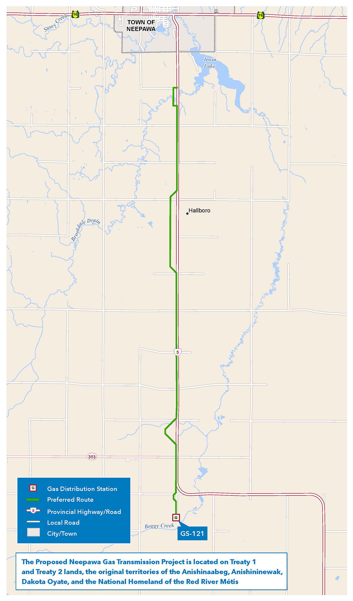
The preferred route for the Neepawa gas transmission pipeline (solid green line).
Enlarge image: Preferred route map for the Neepawa gas transmission pipeline.
The Neepawa Gas Transmission Project is a proposed approximate 19-kilometre, six-inch steel natural gas pipeline. The line will extend from an existing valve site located approximately 22.5 kilometres south of Neepawa, running 19 kilometres north to another control structure located 3.5 kilometres south of the town. It will connect to existing infrastructure, supporting the system’s ability to meet current and future demand in the area.
The purpose of this project is to increase the supply of natural gas to the Neepawa region in response to growing customer demand. The existing infrastructure is nearing capacity, necessitating expansion to support ongoing regional development. Key drivers of this demand include urban growth, the expansion of cereal crop production, and a shift by some users from alternative energy sources to natural gas.
The proposed pipeline is located within the Rural Municipality of North Cypress-Langford south of the Town of Neepawa, and is located on Treaty 1 and Treaty 2 lands, the original territories of the Anishinaabeg, Anishininewak, Ininewak, and the National Homeland of the Red River Métis. We acknowledge these nations who have occupied and cared for these lands for thousands of years and their longstanding cultural and spiritual connections with the land. Through this we recognize the importance of learning and considering the unique perspectives these nations share throughout the project.
Construction methods for this project include trenching and horizontal direct drilling. Trenching involves digging a long narrow hole in the ground and placing the pipeline within it. Typically, the trench is 1.3 meters deep with the top of the pipe lying 1 meter below the surface. Horizontal directional drilling is a method used to install underground utilities, like pipelines. A tunnel that follows an arc shape is drilled under the designated area, and the pipeline is pulled through this tunnel, coming out on the opposite side. Horizontal directional drilling is used to install the pipeline where it crosses areas such as drains, railways and roadways.
This project is classified as a Class 2 development under The Environment Act. An environmental assessment report will be developed and submitted for this project.
How to participate
We plan to work directly with First Nations, the Manitoba Métis Federation, landowners, interested parties and the general public throughout the project lifecycle to:
- share information about the project
- understand and consider concerns and interests
- offer opportunities to participate and inform the environmental assessment process, route alignment, and potential mitigations
We thank everyone who provided their feedback and participated in the engagement process for this project. While our formal engagement activities have ended, we remain open and responsive to any questions or concerns that may arise as we work to file the environmental assessment report and through the project's regulatory review process. This page will be updated as the project progresses through the regulatory review process and project construction.
Timeline
- engagement: September–October 2025
- file environmental assessment report for regulatory review: December 2025
- anticipated Environment Act licensing decision: winter 2026
- if license is approved, anticipated construction start: spring 2027
- estimated in—service date: fall 2027
Updates
Environmental assessment report filed: December 2025
We submitted our environmental assessment report (PDF, 21.8 MB) to the Environmental Approvals Branch of Manitoba Environment and Climate Change for regulatory review in December 2025.
Pre-engagement: September 2025
We’ll reach out to First Nations, the Manitoba Métis Federation, landowners and those interested to understand engagement preferences and considerations.
Resources
Additional information on the project is available from these resources:
Featured resources
- Environmental assessment report (PDF, 21.8 MB)
- Environmental assessment appendices (PDF, 12.7 MB)
- Preferred route map (PDF, 718 KB)
GIS data
This zip file contains spatial files in ESRI Shapefile format of the project infrastructure. They are viewable using geographic information system software. We recommend extracting the files to your computer, rather than opening them online. The .kml file will allow you to view the route(s) with software such as Google Earth®.
Do not download these files if they are beyond your computer’s or internet connection’s ability as they can cause your computer to temporarily stop working (require a restart).
- Final preferred route (Zip file, 14 KB)
Round 1 engagement materials
- Engagement summary – what we heard (PDF, 572 KB)
- Presentation slides (PDF, 2.7 MB)
- Storyboards (PDF, 1.7 MB)