Project overview
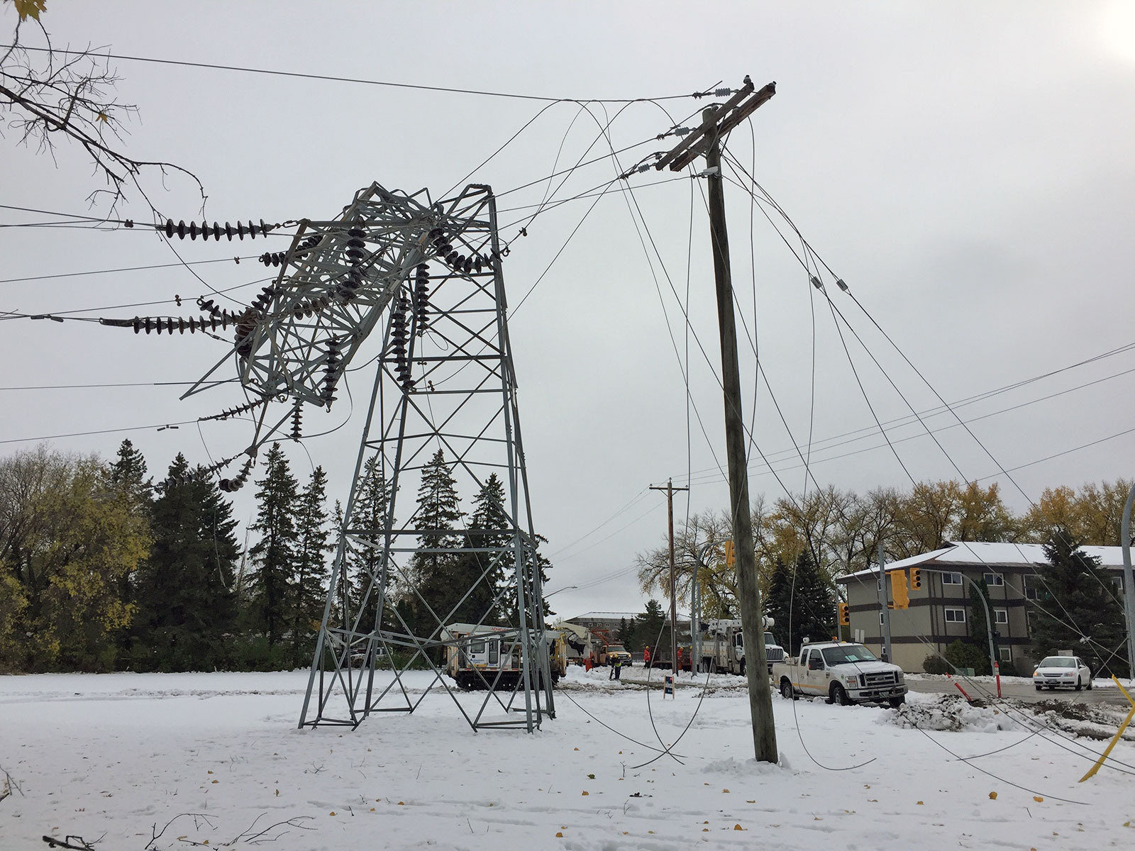
More than 50 towers on BP6/BP7 were damaged by the storm.
Enlarge image: A tower is bent in half beside a hydro pole with downed lines as a result of a storm.
In October 2019, a powerful storm ripped through southern Manitoba. A mix of freezing rain, wet snow, and high winds caused extensive damage to Manitoba Hydro’s system unlike anything seen before. Due to the extent of the damage from the storm, some sections of BP6/BP7, which is a double circuit transmission line between Brandon and Portage la Prairie, need to be entirely rebuilt with permanent replacements. Since development beside the line has grown and requirements for right-of-way widths have increased since the line was first built, different routes were considered for the sections to be rebuilt.
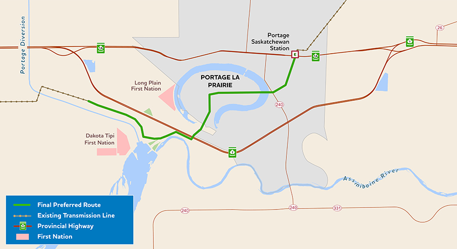
The final preferred route for BP6/BP7 (solid green line).
How to participate
We thank everyone who provided their feedback and participated in the engagement process for this project. While our formal engagement process to inform the environmental assessment has ended, we remain open and responsive to any questions or concerns that may arise through the project’s construction and operation. The project webpage will continue to be updated as the project progresses through project construction.
Timeline
- engagement: July 2020 – April 2021
- file environmental assessment report for regulatory review: April 2021
- licence received: July 2022
- construction start: Spring 2025
- anticipated in-service: February 2026
Timeline is subject to change.
Updates
BP6/BP7 in service: February 2026
The Brandon-Portage la Prairie Transmission Line (BP6/BP7) is now energized and in service. This transmission line provides a permanent replacement for infrastructure damaged in the October 2019 storm, which ensures that we can continue to reliably meet the region’s growing electricity needs well into the future.
While physical construction of the Brandon–Portage la Prairie Transmission Line is complete, final inspections, deficiency corrections and the removal of decommissioned infrastructure are ongoing. We plan to do most of this work this spring as ground conditions allow.
Although the transmission line is now operational, you may still see crews within the easement area to conduct routine maintenance and complete required repairs to the electrical system.
Upcoming implodes: November 2025
As part of the Brandon-Portage la Prairie transmission project (BP6/BP7), we’re moving on to the stringing phase of the project. Part of the work involves fusing metal conductor lines together. To do that, we use an implosion sleeve to safely and effectively create a permanent, high-quality connection.
An implosion sleeve makes a loud noise and flash similar to a firework. If you see or hear a loud noise or a flash, don’t panic, it’s probably us.
Over the next five weeks, implosion sleeves will be used sporadically throughout the project area. Proximity, wind and other factors will affect how clearly you will hear the noise. Before each detonation, workers blow a loud horn.

Implosion sleeves and why we use them
Brandon and Dauphin used implosion sleeves for a transmission structure in Brandon.
Video: 1:21
Resources
Additional information on the project:
Featured resources
- BP6/BP7 final preferred route map — June 2021 (PDF, 1.1 MB)
- BP6/BP7: What we heard summary (PDF, 214 KB)
- BP6/BP7 Environmental Assessment Report — April 22, 2021 (PDF, 35 MB)
- BP6/BP7 License #3382 — July 13, 2022 (PDF, 300 KB)
Round 2
- BP6/BP7: Preferred route map detail – March 2021 (PDF, 1.2 MB)
- BP6/BP7 information sheet – March 2021 (PDF, 178 KB)
- BP6/BP7 virtual information session presentation (PDF, 1.7 MB)
Round 1
- BP6/BP7: What we heard summary – March 2021 (PDF, 461 KB)
- BP6/BP7: Information sheet – October 2020 (PDF, 69 KB)
- BP6/BP7: Alternative route segments map – October 2020 (PDF, 3.7 MB)
- BP6/BP7: Virtual information session presentation – November 2020 (PDF, 4.4 MB)
GIS data
This zip file contains spatial files in ESRI Shapefile format of the project infrastructure. They are viewable using geographic information system software. We recommend extracting the files to your computer, rather than opening them online. The .kml file will allow you to view the route(s) with software such as Google Earth®.
- Project components (Zip, 9 KB)