Project overview
The Portage area capacity enhancement project is a planned expansion of our transmission system in the Portage la Prairie area. The project includes a new electrical station (Wash’ake Mayzoon Station) and transmission line (Dorsey to Wash’ake Mayzoon Transmission Line) to better serve customers in the area and meet growing electricity needs for years to come.
Dorsey to Wash’ake Mayzoon Transmission Line (D83W)
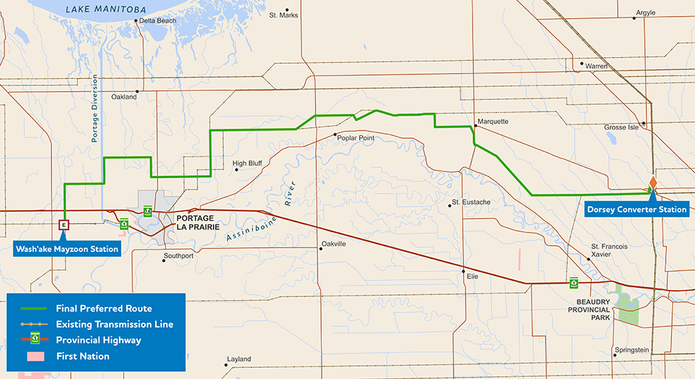
The final preferred route for the D83W transmission line.
We’re planning to build a new 230-kV transmission line from Dorsey converter station (northwest of Winnipeg) to the new Wash’ake Mayzoon station (West of Portage la Prairie).
The new transmission line will increase system capacity to meet growing electricity needs and enhance reliability for customers in Portage la Prairie and surrounding areas.
Wash’ake Mayzoon Station
The Wash’ake Mayzoon Station will help enhance electrical reliability in the Portage la Prairie area. Growth in the Brandon and Portage la Prairie Region, including the addition of new industrial customers, is increasing electricity demand. To meet these needs, we built a new 230 to 66-kV electrical station and a short double circuit transmission line to connect into the existing P18C Tap transmission line.
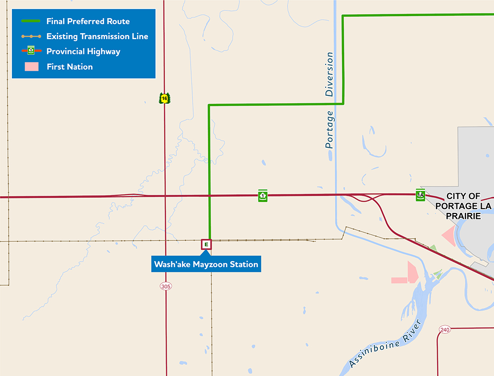
Map of new Wash’ake Mayzoon Station
Working closely with Indigenous community coordinators to better understand concerns and to reduce effects in a manner that makes sense to those involved was an important aspect of this project. When it came to naming the new station, we reached out to the coordinators to ask if they had a suggestion. The Dakota and Métis coordinators worked together to arrive at the name Wash’ake Mayzoon station. Wash’ake translates to power in Dakota, and Mayzoon translates to house in Michif. Although these two words would not make sense together in either language, together they represent a new way of working together on transmission projects and even sound (wa-shock-ee may-zoon) a little like electricity!
How to participate
We thank everyone who provided their feedback and participated in the engagement process for this project. While our formal engagement process to inform the environmental assessment is over, we’re open and responsive to any questions or concerns that may come up through the project’s construction and operation.
Timeline
Wash’ake Mayzoon Station
- engagement: March to August 2021
- file environmental assessment report for regulatory review: September 2021
- license received: December 2021
- construction start: July 2023
- anticipated in-service: May 8, 2025
Dorsey to Wash’ake Mayzoon transmission line (D83W)
- engagement: October 2021 to November 2022
- file environmental assessment report for regulatory review: November 2022
- licence received November 2025
- transmission line construction start: May 2026
- target in-service date: March 2028
This timeline is subject to change.
Updates
Receipt of license: December 2025
The Government of Manitoba has issued Environment Act Licence No. [3455] for the Dorsey to Wash’ake Mayzoon (D83W) transmission line, as part of the Portage Area Capacity Enhancement project (PACE). The licence allows Manitoba Hydro to construct D83W, a 98 kilometre, 230-kV transmission line that will originate at the Dorsey Converter Station and terminate at Wash’ake Mayzoon Station, west of Portage la Prairie.
Read the licence on the Manitoba Government’s Public Registry
Construction completed at Wash’ake Mayzoon Station: March 2025
Construction at the Wash’ake Mayzoon Station is now complete. Commissioning work has started and the in-service date is expected to happen on May 8, 2025.
D83W Environmental Assessment filed: November 2022
This project is classified as a Class 2 development under The Environment Act. An environmental assessment is a multi-disciplinary evaluation of a project that examines what potential effects the project might have on the human and natural environment and how to minimize potential effects. An environmental assessment report has been developed and was submitted in November 2022 to the Environmental Approvals Branch of Manitoba Environment and Climate Change for review.
Resources
Additional information on the project:
Featured resources
- Wash’ake Mayzoon Station: What we heard summary (PDF, 103 KB)
- Wash’ake Mayzoon Station Environmental Assessment Report — September 2, 2021 (PDF, 23 MB)
- Wash’ake Mayzoon Licence #3369 — December 24, 2021 (PDF, 196 KB)
- D83W final preferred route map — November 2022 (PDF, 587 KB)
- D83W Environmental Assessment Report — November 10, 2022 (PDF, 59 MB)
- D83W Licence #3455 – December 2025 (PDF, 472 KB, externally hosted)
Round 2
- Dorsey to Wash’ake Mayzoon: Virtual information session presentation – March 2022 (PDF, 1.5 MB)
- Dorsey to Wash’ake Mayzoon preferred route map – February 2022 (PDF, 439 KB)
- Dorsey to Wash’ake Mayzoon preferred route map detail – February 2022 (PDF, 347 KB)
- Dorsey to Wash’ake Mayzoon: What we heard engagement summary – February 2022 (PDF, 98 KB)
- Dorsey to Wash’ake Mayzoon information sheet – February 2022 (PDF, 691 KB)
- Dorsey to Wash’ake Mayzoon preferred route mapbook – February 2022 (PDF, 12.6 MB)
Round 1
- Dorsey to Wash’ake Mayzoon: Virtual information session presentation – November 2021 (PDF, 1.2 MB)
- Dorsey to Wash’ake Mayzoon station: Transmission line index map of alternative route segments (PDF, 7 MB)
- Dorsey to Wash’ake Mayzoon station: Transmission line alternative route segments maps (PDF, 23.8 MB)
- Dorsey to Wash’ake Mayzoon: Information sheet (PDF, 307 KB)
- Wash’ake Mayzoon Station: What we heard summary (PDF, 103 KB)
- New station map (PDF, 259 KB)
- PACE Information sheet (PDF, 163 KB)
GIS data
This zip file contains spatial files in ESRI Shapefile format of the project infrastructure. They are viewable using geographic information system software. We recommend extracting the files to your computer, rather than opening them online. The .kml file will allow you to view the route(s) with software such as Google Earth®.
Do not download these files if they are beyond your computer’s or internet connection’s ability as they can cause your computer to temporarily stop working (require a restart).
- D83W final preferred route (Zip, 9 KB)
- D83W preferred route – Round 2 (Zip, 10 KB)
- D83W alternative route segments – Round 1 (Zip, 8 KB)